Will Highway 101 Flood at Lucky Drive?
The highest tide this week is Wednesday Nov 25 at 10:49 AM, about 8.3 ft at the San Francisco gauge. That is about the level that put Highway 101 under water at Lucky Drive on January 3, 2026. Thanksgiving and Christmas have tides that high too.
Holiday King Tides on Highway 101
The biggest tides of the year fall around Thanksgiving, Christmas and New Year's, right when everyone is driving. Each day's high tide is shown at NOAA's San Francisco gauge, the same gauge that measured the January 2026 floods, so the numbers compare straight across.
Thanksgiving 2026
January flood levelThe Nov 25 high is as high as the tides that put 101 underwater in January.
- Tue Nov 24 8.2 ft high at 10:05 AM If it floods like Jan. 3, water could be on 101 about 9:05 AM to 4:05 PM. Tide table 6.9 ft, estimated 8.2 ft from NOAA's gauge
- Wed Nov 25 8.3 ft high at 10:49 AM If it floods like Jan. 3, water could be on 101 about 9:49 AM to 4:49 PM. Tide table 7.0 ft, estimated 8.3 ft from NOAA's gauge
- Thu Nov 26 8.2 ft high at 11:38 AM If it floods like Jan. 3, water could be on 101 about 10:38 AM to 5:38 PM. Tide table 7.0 ft, estimated 8.2 ft from NOAA's gauge
- Fri Nov 27 7.9 ft high at 12:31 PM If it floods like Jan. 3, water could be on 101 about 11:31 AM to 6:31 PM. Tide table 6.7 ft, estimated 7.9 ft from NOAA's gauge
- Sat Nov 28 7.5 ft high at 1:28 PM Tide table 6.2 ft, about 7.5 ft if the water keeps running 1.2 ft over it
Christmas 2026
January flood levelThe Dec 24 high is as high as the tides that put 101 underwater in January.
- Wed Dec 23 8.4 ft high at 9:46 AM If it floods like Jan. 3, water could be on 101 about 8:46 AM to 3:46 PM. Tide table 7.2 ft, about 8.4 ft if the water keeps running 1.2 ft over it
- Thu Dec 24 8.5 ft high at 10:37 AM If it floods like Jan. 3, water could be on 101 about 9:37 AM to 4:37 PM. Tide table 7.2 ft, about 8.5 ft if the water keeps running 1.2 ft over it
- Fri Dec 25 8.3 ft high at 11:30 AM If it floods like Jan. 3, water could be on 101 about 10:30 AM to 5:30 PM. Tide table 7.1 ft, about 8.3 ft if the water keeps running 1.2 ft over it
- Sat Dec 26 7.9 ft high at 12:24 PM If it floods like Jan. 3, water could be on 101 about 11:24 AM to 6:24 PM. Tide table 6.7 ft, about 7.9 ft if the water keeps running 1.2 ft over it
New Year's 2027
Below January flood levelThe highest tide these days is below January's flood level. It would take a strong storm to push it up there.
- Thu Dec 31 7.1 ft high at 5:35 AM Tide table 5.9 ft, about 7.1 ft if the water keeps running 1.2 ft over it
- Fri Jan 1 7.3 ft high at 6:16 AM Tide table 6.1 ft, about 7.3 ft if the water keeps running 1.2 ft over it
- Sat Jan 2 7.3 ft high at 7:02 AM Tide table 6.1 ft, about 7.3 ft if the water keeps running 1.2 ft over it
Flood hours run from 1 hour before the high to 6 hours after, the way January 3 played out. Days more than a week away assume the water keeps running as far over the tide tables as it has for the last 30 days.
Highway 101 Tides This Week
Each day's highest tide, from the tide table and from what NOAA's gauge says the water is really doing.
| Day | High tide | Tide table | Estimated | On 101 |
|---|---|---|---|---|
| Sat Nov 21 | 8:15 AM | 6.0 ft | 7.3 ft | Below January flood level |
| Sun Nov 22 | 8:48 AM | 6.4 ft | 7.6 ft | Below January flood level |
| Mon Nov 23 | 9:25 AM | 6.7 ft | 8.0 ft | Close to January flood levelRiskiest about 8:25 AM to 3:25 PM |
| Tue Nov 24 | 10:05 AM | 6.9 ft | 8.2 ft | Close to January flood levelRiskiest about 9:05 AM to 4:05 PM |
| Wed Nov 25 | 10:49 AM | 7.0 ft | 8.3 ft | January flood levelRiskiest about 9:49 AM to 4:49 PM |
| Thu Nov 26 | 11:38 AM | 7.0 ft | 8.2 ft | Close to January flood levelRiskiest about 10:38 AM to 5:38 PM |
Heights in feet above MLLW at San Francisco. 8.2 ft or more is within a few inches of the 8.4 ft tide that flooded 101 on January 3. 7.8 to 8.2 ft matches January days that came close without a freeway closure. Rain, wind and storm surge can push the water higher than any estimate.
When Highway 101 Flooded in January 2026
King tides and back-to-back storms flooded Marin for days in early January 2026. Here is what the San Francisco gauge read each day, next to what the tide table said and what happened on the freeway.
| Day | Tide table | Measured | What happened on 101 |
|---|---|---|---|
| Thu, Jan. 1 | 7.0 ft | 7.9 ft | No freeway closure found in news coverage. |
| Fri, Jan. 2 | 7.2 ft | 8.1 ft | No freeway closure found in news coverage. |
| Sat, Jan. 3 | 7.1 ft | 8.4 ft | All lanes closed at Lucky Drive about noon under 2 to 3 ft of water. Cars stranded, one floated away. One lane each way at 2:30 pm, all lanes at 4:30 pm. |
| Sun, Jan. 4 | 6.9 ft | 7.9 ft | No freeway closure found in news coverage. |
| Mon, Jan. 5 | 6.5 ft | 7.6 ft | Ramps closed at Lucky Drive and the northbound exit to Highway 1, with rain still falling. |
The tides were only about 7 ft on the table. Storms and a bay already running high added about a foot or more, and on January 3 that was enough to put water over the lanes. This fall the bay has been running 1.2 ft over the tables even on calm days, which is why the Thanksgiving and Christmas tides look so much like January's.
Measured peaks from NOAA's San Francisco gauge (9414290). Closures from the Press Democrat, The Ark, ABC7 and KQED.
Will CHP or Caltrans Close 101 Ahead of Time?
Don't count on it. On January 3, Caltrans closed every lane at Lucky Drive around noon, after what the Press Democrat called "rapidly rising water that inundated Highway 101." The CHP posted its traffic advisory at 12:18 pm. County officials said later that traffic was already backing up before the freeway closed, and the county's emergency director wrote that "both the community and government agencies must be prepared to take proactive action."
So plan as if nobody will close it for you. When a tide is near January's level, drive well before the high or wait until late afternoon. For Thanksgiving week, Corte Madera says to expect flooding and road closures from November 22 to 28, with the highest tides between 9 am and 2 pm, and that the water will likely top January's levels on November 24, 25 and 26.
To see closures as they happen, check Caltrans QuickMap and the Marin County emergency portal, and sign up for AlertMarin and Nixle.
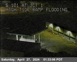
Highway 101 Flood Cameras
Caltrans traffic cameras near the two low spots. The stills reload every minute while this page is open.

All Marin Flood Webcams →
The Shoreline Highway flood cam, Sausalito's waterfront, creek cams and every Caltrans camera in Marin.
Marin County Flooding Today →
A live map of which streets are likely under water right now, plus creek levels and flood alerts.
Get an email the day before a king tide and whenever the water runs high.
Highway 101 Flooding Questions
Will Highway 101 close for the king tides?
Caltrans did not close it ahead of time in January 2026. It closed 101 at Lucky Drive around noon on January 3, after water was already over the lanes, and county officials said traffic was backing up before the closure. To judge a tide, compare it to that day: the San Francisco gauge read 8.4 ft when the freeway went under. Days at 7.9 to 8.1 ft that week had no freeway closure in the news.
Where does Highway 101 flood in Marin?
The low stretch at Lucky Drive, between Corte Madera and Larkspur, is the spot that went under in January 2026. The Highway 1 exit by the Manzanita park and ride in Mill Valley floods too, and it was closed during the same king tides.
What time of day does 101 flood at Lucky Drive?
Around the morning high tide during winter king tides, and for hours after it. On January 3, 2026 the tide peaked at 10:18 am, the freeway closed around noon, and it did not fully reopen until 4:30 pm. For Thanksgiving week 2026, Corte Madera said the highest tides fall between 9 am and 2 pm each day and told people to plan travel around them.
Where can I check if 101 is closed right now?
Caltrans QuickMap (quickmap.dot.ca.gov) shows live closures on 101. The Marin County emergency portal (emergency.marincounty.gov) posts major closures, and AlertMarin and Nixle send alerts to your phone. The Caltrans cameras below show the freeway itself.
Why is the water higher than the tide tables?
Over the last 30 days the San Francisco gauge has averaged 1.2 ft above NOAA's predictions. In October 2026 the bay had its highest monthly average level in NOAA's San Francisco record, which goes back to 1897. Storms push the water higher still.
Why tides are so high right now
Tide predictions and live water levels from NOAA CO-OPS. This page compares tides to past flooding; it is not an official forecast or a closure notice. For emergencies call 911.